MI 841- Spartan Parking
User Observation
Ethographic Research Executive Summary
Parking at Michigan State University is the subject of the ire of students and staff alike. With the combination of more students on campus now than ever before and fewer parking spaces as a result of making the campus more “green”, the parking situation has increased in visibility and importance. It is common to hear complaints like the quotation above across campus when you bring up parking as a subject. In order to continue growing, Michigan State needs to make a concerted effort at making parking less of a user problem by utilizing existing technology. By installing a “mesh” network of Bluetooth beacons across parking lots and garages and creating a smartphone app, Michigan State can move forward in the search for less dreadful parking. Pressure on existing parking resources is still increasing; we need to look at this problem now because the problem won’t fix itself in time.
Introduction
People complain about parking for one of a few reasons; it’s too expensive; it’s too much of a hassle; it’s too limited. People want a better parking experience on campus, and I’d like to make parking better for staff who rely on the use of a parking ramp near Bessey hall. This ramp sees the same drivers every day pull in and hunt for a spot, only to find that sometimes the upper levels have room in them all day, and sometimes they don’t. I started the observation project to discover what might be done about this, while also learning more about who parks there and how they end up in their selected spots. In an ideal world, this project would lead to a solution that helps identify the best remaining parking places in any user-defined area within campus, in order to make parking at MSU less of a hassle for the 12,000 academic and support staff that must find a way to park each and every day. For now I am starting small, by asking the question of “how do people choose their parking spots?” specifically targeted within Ramp 2 on MSU’s campus.
Methods
I chose the Bessey hall parking ramp (Ramp 2) because it experiences mixed use throughout the day. Although it is gated, students enter either by riding close in behind a staff member, or arriving before 8AM, when the gates activate (prior to 8AM, the gates remain open), I sought to find out what people did while parking and after parking their cars, how often they forgot the location of their car, and whether the type of car impacted which parking spaces they chose.
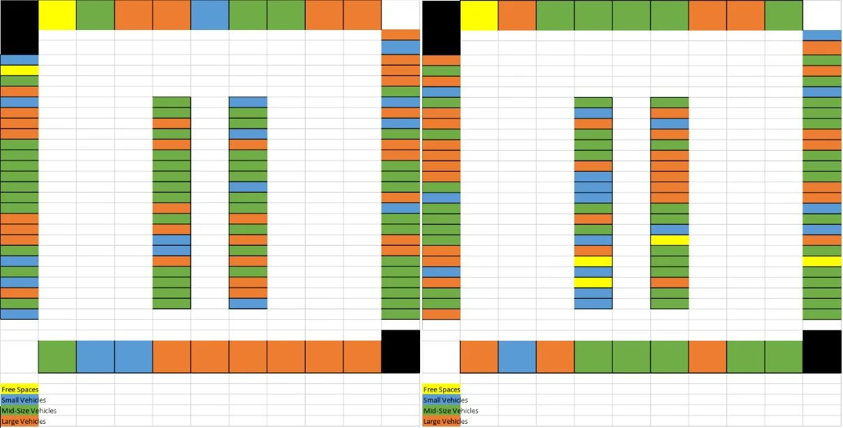
Ramp 2 Parking Spot Diagram
Ramp 2 is located near the corner of Farm Lane and Auditorium Road, next to Bessey hall. It contains 6 levels of parking (Ground, 1st-4th floors, and a Rooftop parking area. Both the ground floor and the 1st floor contain numbered permit spots, usable only by specific staff or faculty members. Because of the scope of my research, I eliminated these floors from my sample. The rooftop area contained a different number of parking spots than the remainder of the building, so it too was removed from the sample. I narrowed my observation location to just the 2nd and 3rd floors because I was unable to acquire the help of anyone. Because I did this alone, I had to be realistic about my abilities to observe. Both the 2nd and 3rd floor contained the same floor plan- each had 111 parking spots, which I divided into North, South, Northwest, Northeast, Southeast, and Southwest. Observations were made in two distinct ways; firstly, I counted all cars on these two levels 4 times throughout a workday, and categorized them as small, mid-sized, or large vehicles. This was in order to track parking preferences based on vehicle size and also to keep track of space utilization throughout the day. Secondly, I observed drivers exiting and entering the parking garage, noting what kind of car they had (again, large, mid-sized, or small), where they parked their car (or where they were going to retrieve it), whether they were walking to or from their car, and what they were doing while walking to or from their car. Drivers were categorized by age, gender, and assumed status in relation to the university (Student, Faculty, or Staff), which was based on what they were carrying and how they were dressed (a staff member would likely not be clothed in sweatpants carrying a sports bag; a student will not likely be carrying a briefcase while wearing a suit and tie).
Findings
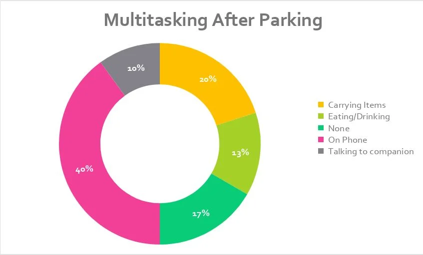
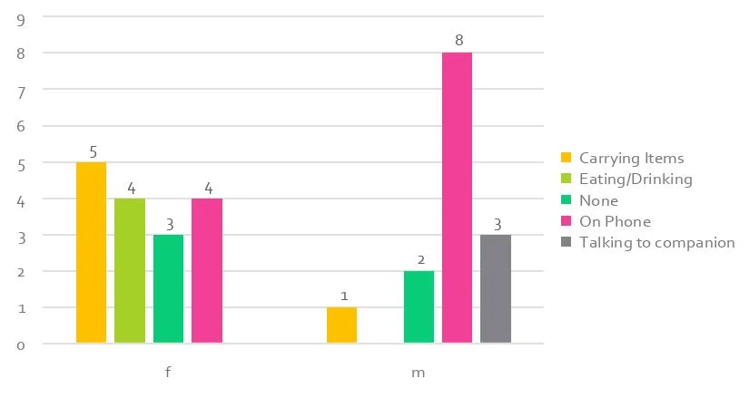
Multitasking Actions
Men checked phones more (8 of the 12 drivers using their phones were male), while women were found to be occupying themselves with other things.
Because so many people are trying to do multiple things at once, parking garages could be very hazardous places to drive. If everyone is doing something in addition to walking/driving, their attention is split, leaving potential holes in their vision. Since many people are already looking at their phones, maybe there is a way to set up Bluetooth beacons to help guide users to and from their cars, while also reminding them to keep their heads up.
Car size impacting Parking Location
Despite only ever making up about 30% of the total number of cars across the 2 observed levels, large vehicles (large SUVs and Trucks) made up approximately 50% of all cars parking on the North and South sides of the garage (large vehicles are shown in orange in the diagrams).
arge vehicles made up a slightly higher percentage of cars parked on the north and south sides than the total ratio of large cars to total number of cars. It was also observed that larger cars were more likely to back into a spot than mid-size or small cars. Although I have no data to support this statement, I believe that it is true, based on the few large vehicles that parked in front of me; because large vehicles have a larger turning radius, it is hard to make a “one point” turn into a parking space, so drivers take the extra time to back in to make it easier on themselves when they leave. It’s also worth noting that the north and south parking areas appeared to have slightly wider parking spaces than anywhere else, which is obviously attractive to large vehicles.
Knowing that large vehicles are choosing wider spaces and observing that large vehicles back into spaces more often can help us understand a problem that over 30% of all drivers (large vehicle drivers) face- parking in small spaces with big cars. This could help us design an application or tool that allows the user to choose their type of car and return to them viable parking options across s user-defined area of campus.
Getting Lost
Something that came out of initial discussions of this project was that after a hard day of work, it can be very easy for some people to forget where they park their car, or “lose” their car temporarily.
During observation, a total of 7 drivers were observed as getting “lost”. “Lost” tag was given to a driver when they suddenly switched directions while in the parking garage. Reversing directions indicates that either the driver has left something in their car (or at their previous location), or that they do not know where their car or the parking garage exit is. 6 of the observed 7 people who were “lost” were heading back to their cars.
While observing, only 7 out of 30 drivers were seen as “lost”, but this could be for one of a few reasons; the data set was skewed towards earlier time frames, and I was unable to observe at a time when many people are leaving, which means that a very large percentage of drivers had yet to attempt to find their cars yet; another explanation is that most people do not have this problem of forgetting where their car is. Because of conversations with both the MI 841 class and with friends and coworkers at MSU, I am inclined to believe that the former explanation is reality. Knowing that forgetting where we park is an issue gives legs to the aforementioned idea of creating a Bluetooth beacon network that will help you identify where you parked before you arrive. Creating a tool that provides a user with this ability seems like a viable solution.
Spartan Park Prototype
Try out my prototype!! Link: https://invis.io/FM9ER85PV
I decided to make a prototype of an application that would begin to solve the issues that I discovered in my Parking user observation. The imagined app would have 3 pieces to it; finding parking spaces, finding a parked vehicle, and viewing a campus map. This prototype was built as a guided interaction with a user (the researcher would ask the user to complete certain tasks with the provided prototype. The following questions were asked in the design of this prototype:
Guided Interaction Questions:
Where would you go if you wanted to find an open parking space?
How would you bring up the filtering menu?
How would you return only lots available to students?
How would you find more details about a specific lot?
Design Questions to Answer:
What is the best way to convey a user's current location?
What sort of parking filters are hlepful and unhelpful?
What information do users want about parking lots?
What's the best way to help familiarize users with the application?
I used InVision, because I have used it in the past and I like how quickly I can whip something up in photoshop and make it interactive. The guiding questions each tackle a different point of interaction. I want to make sure that people understand via icons and points of reference where they currently are located (represented in the prototype by the black location pin). I am curious to know how else parking might be searched for (I took the low hanging fruit of parking for students, faculty/staff, and guests); I’m certain there are other ways it might be categorized. I included basic information about the parking lot included in the prototype, but again, I’m guessing that people who park in different lots each have different expectations for what “relevant information” means. I have also always been curious how to make an on-boarding experience pleasant. By guiding the user through an interaction (from opening the app to finding the details about lot 79), I think that I can gain valuable knowledge about these questions, by both deductive reasoning (it took the user a long time to figure out tapping on a parking lot can show parking availability, so maybe a “tip” in the top filter bar isn’t helpful) and by interviewing users after they complete the guided interaction.


